
In my lowest altitude camp I wake up to negative temps, high humidity and a good frost all over the place as a consequence. This is a classic example of temp inversion driven by sustained high pressure conditions: cold air sinks and humidity condenses. During the night there’s no sun to warm things up so the system stays locked.
I tried to stay away from the actual valley bottom and the stream that goes with it but it didn’t help. Tree cover works wonders but the available terrain was not flat. It was like waking up inside a fridge.
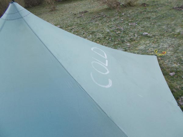
Cold
I have no problem walking the road for the few kilometers to the next saddle on the divide. It’s a very minor road and it runs parallel and at arm’s reach of the actual divide crest. Only for a short while to the Panderrueda pass.
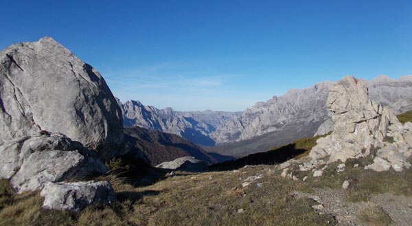
This saddle feels like home more than any other place on the High Route. It’s the access to the Valdeon valley, a most amazing place and my favorite in the area. The pass itself offers a spectacular view of the Picos de Europa, the massive grey walls right in your face are among the most impressive mountain views I’ve ever seen.
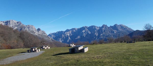
Picos de Europa central massif from Panderrueda pass
I’ve been here many times, the last one in a chilly, rainy morning only one month ago during a cycling tour. It felt like winter then and it feels more like summer today. Air temp is still low but the sun is out and if feels nicely warm. I sit in the picnic tables. I have a decision to make.
Dilemma
I’m on a High Route of the Cantabrian ranges. It’s an open concept that does not necessarily mean sticking to the highest anything but a line reasonably close to the watershed crest. This may include visiting adjacent valleys. No crest dogma. So here below there’s Valdeon, which I’d love to visit again but deep inside I know what it is that entices me: it’d be dead easy hiking.
No bush walking, no route finding, not even room for mistakes, just walking! and the prospect feels great. I could go down to the valley, maybe get a pub meal and be back up on the next crest saddle by day’s end. Or I could take roughly the same amount of time to get to the same place by sticking to the crest, a shorter route that must include allowance for bush walking, route finding and for making mistakes.
The following crest section feels particularly remote. The close presence of the Picos de Europa means nobody pays any attention to these mountains here. There’d be more bears than humans.
I don’t have much information and I need to face the fact that this intimidates me. This is what it is. I feel tired about taking the responsibility and face the challenge. This time, there’d be an straightforward, easy way and I’d love to take it.
Then I see it clear. Purposely avoiding the challenge would defeat the whole reason why I’m here. It’d be pointless. After all, I already had a pub meal in Valdeon just one month ago and back then it was fully justified in the wintery weather. Not today. I’ll take the crest.
Reassured, I resume the hiking.
It’s on the crest
The crest east of Panderrueda pass is gentle and forested, a perfect storm scenario to require intense routed finding in a complex geography area like this one. It’d be surprisingly easy to take the wrong way. I’m super glad to find a good trail and cross fingers hoping it stays.
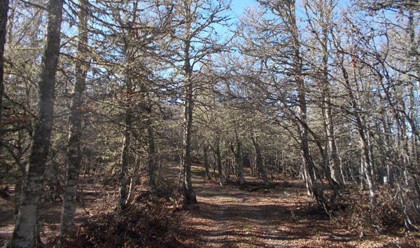
A track through the beech woods
It does. I still hold my breath every time its quality deteriorates, from dirt road to path, then to rough track. Eventually, I get off the forest and on a steeper, narrowing ridge so the route finding will not be an issue anymore. I feel like back to normal life on the crest.
This is the one section I wouldn’t find a single report about prior to my trip. I didn’t actually search thoroughly for one but if there’s one section where I don’t know what to expect, it is this one.
I can see two high peaks ahead, 2K both of them that don’t look difficult. The terrain after that is hidden from view. The map shows high potential for very steep and narrow crest sections but I can’t tell for sure how difficult it can be to go through.
Cebolleda peak is a sweaty affair in the midday sun, other than that an easy climb. The summit provides ace views over the Valdeon valley and the big peaks behind.
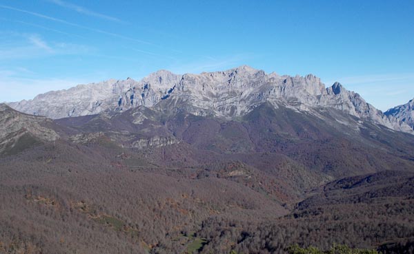
Picos de Europa and the secret valleys
I didn’t anticipate any problems until well after the second peak so I’m surprised by the upcoming ridge being rocky, steep and narrow. The usual problem mix.

Pico Cebolleda airy crest
I peeked over the abyss and quickly decided that I didn’t want to climb down that thing. Once again, it was OK terrain for mountaineering standards but I didn’t feel comfortable traversing it with a heavy pack.
I also took a look ahead to the rest of the now visible crest to find what looked like a real knife-edge section, tightrope walking style.
I had good visibility over the southern flanks all the way beyond all the problem areas so I scouted an alternate route along the hill’s foot.
This is somehow great: I’m improvising! And this makes me feel fully in control of my trip. Even in such an open route as this one, I was still sticking to lines set on a map, either by myself or by the cartographer. Now I’m going off-line. Such a small, silly twist makes a difference.
It’s off the crest
I get off the mountain southwards on the less steep ridge that doesn’t require backtracking until the land flattens 200 vertical meters below and proceed forward along cattle trails. The crest ridge section down from the peak doesn’t look as difficult from here but who knows and who cares.
Two important facts I do care about: number one, progress along the base is easier than I feared. There’s bush but cattle trails are consistently spot on in my intended direction. Number two, feeling in control has me relaxed. I’m starting to really like this.
So much that I stop for lunch, summer style: take off my shoes, wash my feet in a stream, take the wet shelter out to dry and enjoy my food.

Wet shelter no more
The warming sun in mid November may be a sign of impending doom but I will boldly enjoy it this time. It’s the first time I do this on this trip. This is because I feel relaxed.
The prints on the trails I’m following clearly show these are used by cattle: cows and horses. Taking a look at the grand scheme of things, it appears that cattle break tracks through the bush to link meadow grazing areas and travel in between them. These meadows form naturally where the slope eases and the water springs from the high aquifers. It is exactly the line I need to follow and I’m glad to find out how well it’s working.

Engineering courtesy of the local cows
I eventually climb back to the crest to land in a scenic area dotted with huge limestone blocks, no wonder why the area is called White Crags -a recurrent name in limestone areas. I meet again the front view to the Picos de Europa. Fabulous, spectacular.
Fore: White Crags. Back: Picos de Europa western and central massifs with the Cares gorge visible in the middle
Fastpacking
The crest here is wide, grassy and flat and I can’t help but think how great a spot it’d be for my overnight. “I don’t have water”, I argue to myself, somehow justifying what in fact is the tyranny of the fastpacking scheme: you camp when the time comes, not where the place does.
There’s one last 2K peak to climb before coming down to the next road saddle: Pico Gabanceda’s summit is a perfect, attractive limestone pyramid that I skirt over the side. Fastpacking ethos once again.
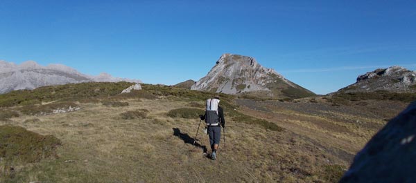
Towards Pico Gabanceda
Once on the other side of the mountain, I can see the future: the Pandetrave Pass road below, a terraced, flat meadow area halfway down and the next section of the Cantabrian range that I’ll go through tomorrow. It’s early evening now and I’d just have time to get down to the road and keep on for a little longer to find a campsite so that would be the plan.
As I proceed down, I get to this flat, grassy area hanging in the middle of the slope. It’s a lovely place encompassing the light grey, limestone outcrops and a perfect view of the Picos de Europa central massif. Then I remember the high pressure + temp inversion scheme that’s going on and convey that camping overnight down in the valley is a bad idea. That would be my fate if I keep descending. It would be wise to camp high tonight and I could have the chance for an early stop.
I’d just miss water. I see a patch of ultra-green grass a bit further down, that usually means it’s wet ground. I check for a possible water course, et voilá… a tiny spring just by the side of what will be my home for tonight: it’s a deal.
The scat-free patch finding challenge is particularly tough today, being a rather small flat area and I eventually need to camp off the view of the Picos de Europa but I also get some shelter from the cold breeze as a compensation.
It’s day 6 and for the first time in the trip I can take camp pics still in daylight and I can have my dinner before darkness.
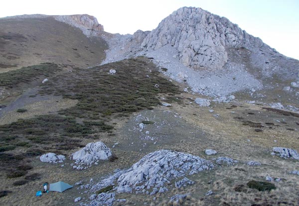
Camp under Pico Gabanceda
I can relax and see the sunset. Feels like real holidays now.
Maps & Track
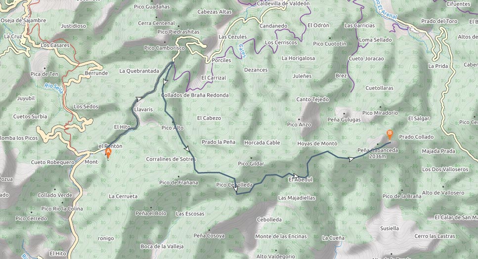
View route map for Cantabrian High Route Stage 6: Arroyo Vallejo – Pico Gabanceda on plotaroute.com
 RSS – Posts
Say what you want