
 Initial stage of my trip on the Via Alpina 1: the Weisstannental and my first ever Swiss Alpine pass
 Stage 2 of my trip on the Via Alpina 1: from the Sernftal to Urner Boden
 Stage 3 of the Via Alpina 1: Klausenpass, a long descent and a big, flat valley plus my first real crisis of the trip
 Via Alpina 1, Stage 4: one high pass in the morning, a second one in the evening and everything in between
 Stage 5 of my trip on the Via Alpina 1: the Planplatten ridge, postcard panoramas and a camp spot guarded by the Wetterhorn
 Via Alpina 1, Stage 6: the two towers (a.k.a. Wetterhorn and Eiger)
 Day 7 on the Via Alpina: dark weather, dark rock and the toughest side of thru-hiking when the body doesn't work
 8 is the final day of my trip on the Via Alpina, coming out of illness to climb the last passes with the odd names
Tag: Diaries

| Start | Bundalp |
| End | Adelboden |
| Distance | 31 km / 19 m |
| Passes | Hohtürli, Bunderchrinde |
I wake up wondering if I’ll be fit for walking today. It’s difficult to say when nothing really hurts and a resting position makes everything feel right. Straight off bed I feel weak but that may be normal. I decide to give breakfast a go and see how it feels. It went down this well:

Alp breakfast

| Start | Lauterbrunnen |
| End | Bundalp |
| Distance | 24 km / 15 m |
| Passes | Sefinenfurkke |
For the first time in the trip, the day starts overcast. Chance of rain in the morning, getting dryer in the evening. Me, climbing right away, pretty much off the hostel door and up the glacial escarpment with interesting views back to Lauterbrunnen.

Lauterbrunnen from the other side

| Start | Wetterhorn base |
| End | Lauterbrunnen |
| Distance | 29 km / 18 m |
| Passes | Grosse Scheidegg, Kleine Scheidegg |
After the early night thunderstorm, the morning is crisp and clear. The Wetterhorn is still there.

Dawn on the Wetterhorn

| Start | Engstlensee |
| End | Wetterhorn foot |
| Distance | 33 km / 20 m |
| Passes | None |
I’m glad I slept under tree cover, the Alps are a surprisingly damp place! but my shelter is mostly dry in the early morning and I didn’t need to compromise on views.

Dawn on the Engstlensee, Jochpass at the far end

| Start | Brüsti |
| End | Engstlensee |
| Distance | 36 km / 22 m |
| Passes | Surenenpass, Jochpass |
Morning is brilliant blue and it doesn’t take as long as on previous mornings for the light to shine, it’s the first time on the trip that I don’t sleep on the valley floor. I couldn’t arrange for tree cover overhead for the night but my shelter is dry nevertheless. Surenenpass is still there and it’s my next milestone.

Trailstar in the meadow, Surenenpass at the far end

| Start | Urnerboden |
| End | Brüsti - Attinghausen |
| Distance | 33 km / 20 m |
| Passes | Klausenpass |
In the morning, as expected, everything is dripping wet and I need to leave well before the sun shines so I pack a wet mess and a good excuse for an extended break in the sun later on the day. The setting is not idyllic, too close to human habitation but the valley is beautiful and very well worth a camp pic:

Dawn in Urner Boden

| Start | Elm |
| End | Urnerboden |
| Distance | 42 km / 26 m |
| Passes | Richetlipass |
Morning is dark inside the thick conifer woods where I’m camping just outside Elm village. I go through town in daylight but still well before the sun rises above the mountain tops. My legs are sore from day 1 efforts that no amount of stretching could heal but as soon as I warm them up, I can walk with reasonable dignity.

Morning in the conifer woods

| Start | Sargans |
| End | Elm |
| Distance | 36 km / 22 m |
| Passes | Foopass |
Sargans and nearby Mels sit in a wide, oddly flat valley confluence flanked by high peaks. The Via Alpina 1 enters the mountains along the Weisstannental in a course due west. This valley is narrow and deep, with a public road near stream level. The trail takes a different course on the upper floor, i.e. it makes an initial climb to the south-side slopes, then traverses along, linking the small communities and farms clinging to the hillside.
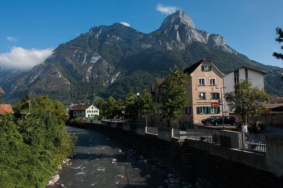
The Seez in Mels
 The first section of my hike on the Newfoundland IAT goes across two mountain groups: the Lewis Hills and the Blow-me-Down Mountains. Wild and remote country in western Newfoundland.
 The second section of my IAT trip goes across the North Arm Hills, a group of mountains north of the Bay of Islands in Western Newfoundland. This story accounts for days 6 to 8 in the trip and starts in a Corner Brook town hotel.
 This section was a necessary transition in both space and time. I needed to get myself from Trout River to Rocky Harbour, Western Newfoundland and sort out some logistics along the way.
 The Northern Traverse and the Long Range Traverse are the two flagship wilderness routes in the Gros Morne National Park. They're a great way of experiencing the highlands of the Long Range Mountains in a sort of controlled environment while keeping the wilderness flavor.
 What can you do for a full day in St. John's when you can barely walk? St. John's is a lovely town with super nice summer weather. If airline schedules mean I have to spend a day here, It'll be a great time no matter what.

I fly into St. John’s in the very early morning, then fly home late at night. What can you do for a full day in St. John’s when you can barely walk1?
St. John’s is a lovely town with super nice summer weather. If airline schedules mean I have to spend a day here, it’ll be a great time no matter what.

St. John’s harbour

The Northern Traverse and the Long Range Traverse are the two flagship wilderness routes in the Gros Morne National Park. They’re a great way of experiencing the highlands of the Long Range Mountains in a sort of controlled environment while keeping the wilderness flavor. The area is high enough for the vegetation to be passable so all you need is an access trail from the lowlands, then you’re good to go.
This section is bound to be the grand finale for my Newfoundland trip. It will include the now popular Long Range Traverse, that I already hiked in my previous visit in 2003, and the Northern (formerly North Rim) Traverse. I have a limit of 5 full hiking days that will account for days 12 to 16 of my trip.

This section was a necessary transition in both space and time. I didn’t want my trip to become a series of unconnected multi-day hikes, I wanted my trip to be a real A to B. I could accept the exception of the Bay of Islands gap, even if half of it was an overland detour rather than a water crossing but I kept to my compromise of hiking every bit that was on my intended line of travel and was not over water.
Now I needed to get myself from Trout River to Rocky Harbour, Western Newfoundland.

To Rocky Harbour

The second section of my IAT trip goes across the North Arm Hills, a group of mountains north of the Bay of Islands in Western Newfoundland.

Distance covered: 27 miles
Today there’s two distinct sections: first I need to finish the Laugavegur, a mostly downhill affaire to the coastal valley of Thorsmork. Then, the steepest, longest climb of the trip to go over the Fimmvorduhals pass and down to trip end in Skogar. The potential for trouble lies in this second half with a pass above 1000 metres and a stormy forecast.
Distance covered: 23 miles
You can get up as early as you want in the Iceland summer. I never got a precise account of what time the sun did rise but I think some “nights” I got to feel ambient light around 3 am before turning back to sleep. Most nights I’m on my own and don’t relate to anyone so it’s not obvious whether I got up early or not if I don’t look at the watch. Today I’m in a tent town that’s still quiet and still when I leave. It must be early even though we’re in full daylight. It’s clear and bright and I get ready for a memorable hiking day.
Distance covered: 19 miles
The day starts dark and moody. Rain spares my packing up but that’s all the respite I get as it soon starts coming down. I’m in high ground so I can see far to south and west and all I see is dark cloud. I get mentally ready for a wet march to Landmannalaugar.
Distance covered: 33 miles
Now that I’m fully aware of how important the weather still is, my first, early morning thought is for a sky update, pee and breakfast will come only later. It turns fairly quiet, cloudy but not overcast and it doesn’t rain. That’s good enough. Let’s go hiking.
Distance covered: 30 miles
I’m now where I dreamt to be when I left Myvatn a long time ago (that’s 4 days). It’s been no death march to get here, in fact it was fairly quiet with some glorious times along the way. Now there’s no expected obstacles to get to the F26, once there I’m in relative safety no matter the weather. I feel less vulnerable. That means I’m less worried by an early morning overcast. Now I’ve got some miles to do.
Distance covered: 25 miles
I get my promised good weather window, it is calm and sunny in the morning. My first sunny day in Iceland 2016!!! Look at that blue sky:

Brilliant blue skies at last. Vatnajokull hides behind low cloud
Distance covered: 32 miles
The weather is still mostly clear when I wake up in the morning. Where’s all that forecasted rain? I don’t want to know. I’m delighted to be able to feel relaxed and eager to start the day’s hiking, first time on this trip that I feel that way. At this stage, my first encounter with the outcome of sandy ground camping is nothing but a minor inconvenience. I’ll need to get used to this black sand all over the place. I feel for the tent but it’s its job after all.
Distance covered: 28 miles
The problem with staying in such a nice hut is that it’s difficult to leave but I have that one clear, early wake-up call and no room for doubt. The weather seems to resume where it left it the day before which is not that bad of a news. It is demanding weather to be outside but far from my fear induced nightmare dreams. It is cloudy, windy, cold and generally unsettled but it is not raining consistently and there are even occasional spells of brightness.
Distance covered: 30 miles
I set out in death-march mood. The sky is severely overcast but at least it’s not raining yet. This is a big help for a start.

Dark day in Myvatn
My Iceland traverse can easily be split into three sections which meet both geographical and emotional criteria: first is easy. Second is difficult. Third is safety. Then it turned out slightly differently.
This is the day-by-day account:


Distance covered: 25 miles
I’m happy to face one final road walk today. The wimp in me got scared yesterday and I’m fine with that middle ground in not giving up but taking the less compromising route. It won’t be a memorable journey but I’ll be worry free no matter the weather. Real wilderness will need to wait a bit longer.
Distance covered: 28 miles
It starts overcast and windy, at least the wind will be on my back. The other good news is that I’ll be on a real hiking trail today. A rare, welcome event, I won’t find another such trail until the final 2 days of the trip. I also know this trail is easy to follow, not only from reports but from previous, own experience, and this is the other, funny part: I was hiking on this trail 16 years back, no less. Back then, the same northerlies as expected today left me dripping wet and cold to the point that I bailed out mid-way. I’m here now to fill that gap.
Distance covered: 29 miles
Day 2 is typically a tough one in fastpacking trips with no quarter. It is the day when the body is already beaten by the previous day’s effort but not yet used to the constant beating of a thru-hike. I can’t take it easy though. If I mean to cross Iceland in 13 days, I can’t just take it easy, not even for one day, not even for day 2.
Distance covered: 28 miles
It’s overcast and gloomy as I wake up in Akureyri but I commit to not worry about the weather, at least until I start the actual hiking. I still need to get to the starting point and that is a few hours bus ride away. This is Iceland and the most mundane bus trip is a spectacular event so I sit back and relax.

The Blue Line between A and B
The complete High Route in the Cantabrian Watershed divide would take at least 2 weeks to cover to a strong, committed hiker. This trip was 8 days long in a season where daylight is getting short, no way I could hike the whole thing. I had a starting point and a way to go. The goal was to hike and be on my own for 8 days in the most magnificent of sceneries.
View route map for Cantabrian High Route Pajares Piedrasluengas on plotaroute.com
I didn’t record the hike so the plot above, drawn by hand, is not accurate, neither is the distance, which came out to 180 km (112 miles)
The menu on the right has the stage breakdown. The names will be meaningless but I need to put a name to the places!
The high pressure conditions remain and the weather should be clear. I don’t know what caused yesterday’s fogs, maybe some cold air mass in the area. I would expect a new, clear day today no matter how dark and thick the fog was yesterday but I have a plan in case it remains: the track I was following would actually take me out of the mountains. It’d be acceptable given this is my last day of hiking.
I wake up to a dry tarp and a view of a frosty valley below, fully endorsing yesterday’s camp choice. Actual site and orientation missed the best mountain view but I could see sunset and sunrise instead:

Good morning
In my lowest altitude camp I wake up to negative temps, high humidity and a good frost all over the place as a consequence. This is a classic example of temp inversion driven by sustained high pressure conditions: cold air sinks and humidity condenses. During the night there’s no sun to warm things up so the system stays locked.
In the morning my tarp is dry and the grass around is dry as the valley bottom has frosted over. What a huge difference a short distance can make in the camping experience and how much nicer it is to pack a dry shelter.

Frost in the valley below
A small cirque at the very headwaters of a cantabrian valley, that’s the definition of the perfect overnight spot and I feel fortunate to wake up in such glorious place. The only downside in a mid-November morning is how long the sun takes to shine. I leave the area before I get a chance of getting any warmth. Morning lights are beautiful anyway.
Yesterday’s last effort was more than a last push for the sake of performance, it was also a statement.
It’s often easy to skip crest sections by joining saddles along the slopes or the base of the hill. This is fine as it is all part of what a High Route means: the idea is to follow a coherent line along the divide. Then there are cases like yesterday evening’s: the road to the ski resort runs parallel to the divide crest and leads to a gentle climb back to the top on a service track. I could have done all that in less than a couple of hours. It is not cheating, it’s just the -in this case- easy way.
The night goes in between heaven and hell. Heaven because that’s what the night usually is: a time to relax, do nothing but rest, heal the wounds of the day’s work, feel at peace with the world. Hell because sometimes the world gets aggressive and you become a tiny piece of nothing at its mercy.
I took the early morning train from Leon to Busdongo de Arbas, 4 km down the road from the Pajares pass in the divide. The train line goes north across the plains and into the foothill mountains, along a narrow, winding valley.
 RSS – Posts