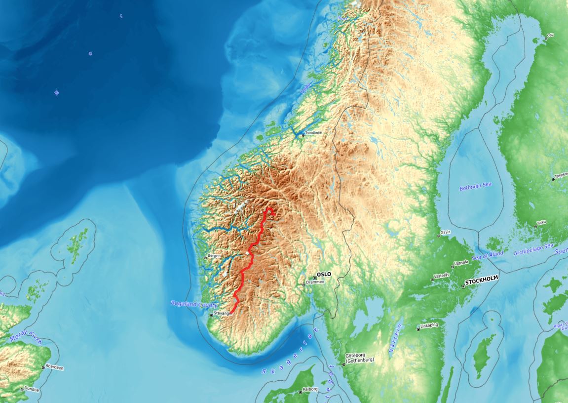
In late summer 2024, I hiked from St. Moritz to Zermatt along the Swiss/Italian Alps. This is a record of the second week, when I walked along a section of the Grande Traversata delle Alpi.

Grande Traversatta delle Alpi
It’s day 8 and I wake up to dark skies again. I can’t even remember what the weather forecast was at the time but it’d look like it wouldn’t matter, the cloud seemed to always be there. As I break camp, it’s got foggy around.

Yet another cloudy morning
It’s a few miles along the hillside on a gravel, wide track that connects a series of alp settings before the junction where I’ll leave the Alpenpässe-Weg that I’ve been following for a week. On the way, what looks like an avalanche path. You can only try to guess the power of it by the downed trees:

Avalanche path
The junction in Alpe di Cristallina is a main milestone, I have been following the Alpenpässe-Weg, Number 6 in the Swiss system, for a week. At the time of planning, it’d look like entering less interesting terrain for a good while so I drew my route over different trails, aiming for the high areas without leaving the trail network. This is where I leave the Alpenpässe-Weg.

Leaving the Alpenpässe-Weg
I leave the hillside walk to climb into the mountains and into the fog. The trail is still easy to follow and the signaling is the usual good.

Good trail, good signaling, good fog
The fog thickens as I climb to Passo di Cristallina, which is not much higher than the several grassy passes I had gone through in previous days but this one is on rocky terrain from a good while below. There’s a hut at the very pass. In the present conditions, I have it very clear that lunch inside will be much nicer.

Capanna Cristallina
I was climbing in my long sleeve shirt but when I leave the hut I need to really layer up, it’s dark, cold and downhill over wet rock, still on a good trail though.

Down from Passo di Cristallina
The fog adds to the drama but it’s a bit of a pity to miss the views for a first time visit to the area. Once off the pass area, it gets quieter and less cold while progress is on the slow side on a wet, rocky downhill.
Halfway through the descent, the trail meets briefly with a gravel road, part of the hydro schemes in the area, that I could keep following for much easier progress but I decide to stick to the trail. The bonus is coffee and cake in Capanna Basodino that the road would have missed. Given the chance, it’s a good move to take a break inside when the outside would quickly lead to being uncomfortably cold.

Capanna Basodino
Up from the hut, it’s the final miles in Switzerland for the time being. After an initial steep climb in the fog, I get to an imposing high valley that leads to beautifully named Bocchetta di Val Maggia and the border with Italy.

Bocchetta di Val Maggia

Switzerland | Italia
It’s on and off the fog down the pass with some old snow that’s probably easier walking than the wet rock.

Old snow
The rock world leads to a high pasture area with grazing cows, shepherds’ huts farther down, then hydro schemes and a CAI hut that I’d had happily stayed in but it’s not raining so I make the final descent to the main valley where I meet a road and Riale village.

Riale, 1729 high
There’s a beautiful looking alpine lodge right by the trail and it’s one of those days when it’s difficult to keep going pass that. I’d almost wish it’d start raining so I’d have the perfect excuse to be inside but it doesn’t.
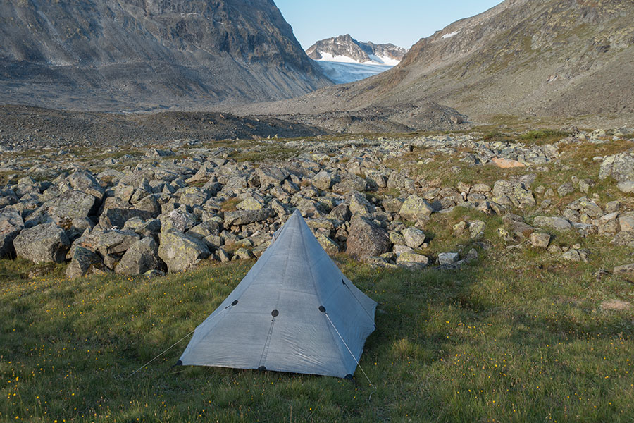
I have just enough daylight, so to speak, left to climb out of the valley floor and find a flat bench to pitch the mid. I have dinner with views over the valley.

Comfy camp
Day 9 is overcast again and the forecast calls for sustained, heavy rain after mid-morning. It looks like a bad day to be outside, less so sleep outside after a full soak so I see my options. There’s a pass upcoming, then I’ll go down to a hut. Then it’s up again another pass followed by a long way down to a road-accessible, recreational area where there’s another hut. I set my beacon to the latter and resume the low mood hiking, heading up Passo Nefelgiu.

Looking back down Vallone di Nefelgiu
It’s a short way down Passo Nefelgiu to dammed Lago Vannino, soon visible down the trail.

Lago Vannino
It starts raining literally 200 m before I go by Rifugio Margaroli, found by the dam and above the lake shore and I have it clear: go inside and ponder my options while I have some coffee and cake.

Rifugio Margaroli
In between a challenging and a conservative approach, my initial plan for the day was to go past Margaroli, climb the following pass and safely come down to Alpe Devero where I’d find another hut to sit my wet bones for the night. It’d be only 13 km more, it shouldn’t be too tough but when I look outside to the now heavy rain, getting out feels like the worst of ideas. The hut warden confirms it should be raining for the whole day.
I change my mind several times as I keep an eye on the degree of darkness outside. On the one hand, staying put would be disastrous for my overall average and my goal of reaching Zermatt at the end of the trip. On the other hand, I still have it recent how tough it was to keep going in a similar situation a few days before and I tell myself I don’t want to go through that again.
It’s only mid morning as wet hikers start pouring into the hut. I tell the wardens I’ll stay for the night.

Main room by the evening in Margaroli, fireplace on and lots of wet clothing around
It did rain solid for the rest of the day. It’s difficult to say how tough it’d have been to keep going to the next hut and whether staying was a good decision. I felt bad about it but at some early point I intendedly stopped mulling over it. No point.
It was a busy day in Rifugio Margaroli with a continuous trickle of wet hikers coming in. I had some time to outline plans for the rest of the trip, relax and enjoy a hefty dinner. Good times.
The next morning wasn’t rainy and the forecast said the worst of the storm had passed but the vibe was still far from quiet. There were spells of light but the sky was often overcast. On the way to 2599 high Scatta Minoia, it got windy and surprisingly cold. Nice view back to Lago Vannino and the Margaroli hut with the distance somewhat blurring the sight of the hydro schemes.

Lago Vannino from the south
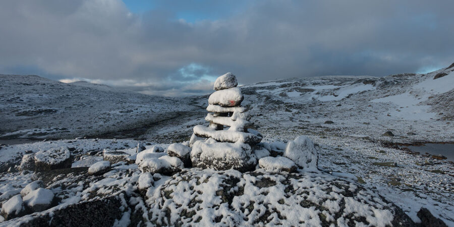
Scatta Minoia is a high enough pass to be mostly rock underfoot. It feels wintry across the saddle with thick, low cloud and a biting wind that makes me welcome the emergency hut at the pass. It’s been just one and a half hour from departure and I’m not tired neither hungry yet but I get inside to get away from the wind while I layer up. The hut is in good condition but the concrete walls don’t make for much warmth.

Builders wanted to make sure you don’t miss this one in low vis conditions
It rains again as I come down the pass, only a shower so nobody gets too relaxed. The weather stays unsettled. On the other hand, the scenery is very nice with a lake basin and alpine meadowland as I approach the tree line.

There were sunny spells. This is not one of them
Further down the valley, the route enters the sheltering woods and this is peace for the hiker tired of fighting. Lago di Devero is the unmistakable reference.

Lago di Devero
Past the lake, there’s Alpe Devero, a wide, roughly circular and fully flat meadowland flanked by high hills all around. It looks like a former lake but if it ever was, it’s long gone. The place is now at the end of a mountain road and it’s partially urbanized in stone and wood mountain style. It’s a beautiful place despite all the modern housing. Together with a lighter cloud that lets some sun through, it quite lifts my spirits.

Alpe Devero
Up from Alpe Devero, the route climbs onto an oddly-oriented headwater area draining northeast between the main alpine divide and a secondary ridge. It’s a beautiful stretch, nicely sheltered alpine meadowland flanked by trees against the backdrop of high, rocky peaks. Grazing cattle enjoys the grass, I enjoy the hiking.

Alpe Buscagna
The route leads to Scatta d’Orogna, a pass into a roughly parallel valley that the trail will side-hill onto Passo di Valtendra, a major east-west notch.

Passo di Valtendra
Could cover had been thickening since the happy hour in Alpe Devero but the vibe was keeping overly quiet. Going across the pass was like entering a new dimension. All of a sudden, I meet darkness, low cloud and a cold wind. Ceasefire’s over. By the time I get down to the grass and trees, it starts raining.

Pian du Scricc
I wasn’t expecting this major rain event but I somehow don’t get too pissed off by it, maybe I’m getting used to but it surely helps knowing that there’s a hut I could use in upcoming Alpe Veglia.
I spend a good while hiding from the rain by the door of the Rifugio Citta di Arona considering options. Alpe Veglia is a beautiful place, a headwater plain with the backdrop of the 3K peaks of the alpine divide. It’s a couple of hours before dark, I’ve hiked 27 km and it’d make all the sense to go the easy way and stay in the hut. On the other hand, my schedule has got so tight after the previous day’s short journey that I really need to hike those two hours. Staying in the hut would literally mean saying goodbye to my goal of reaching Zermatt at the end of the trip. It was an exciting plan and I had been working hard to make it happen. Rain has eased. I decide to keep going.

Alpe Veglia
It’s all downhill from Alpe Veglia on a vehicle-worthy track that saves the major step to the valley floor across a steep hillside. The alp above should have been a hard reach for people and cattle before the track was built.
I try to make the most out of the decision to continue by jogging down the road with the slope in my favour. It’s just quad work but no high exertion. Not the first time I do this on this trip, neither the last. By the time I get to the first village in the valley, it’s raining again and I’m tempted to find accommodation in town but the place is touristy and pretty much dead in the off-season.
Once in populated areas, the issue is to find a quiet, hidden camp spot with the trail traversing a non-level hillside for ages but I spot a flattish area ahead in the map and it works out. Woodland campsite in the dark. Camp pic from the following morning.

Val Divedro woods
Keeping the goal within reach is motivating but also demanding. I need to keep working hard. I had been going through the maps before going to sleep and identified a potential for time saving in the upcoming stretch by changing slightly my route down to Varzo village. My original route takes trails on the hillside while the paved road runs parallel near the valley floor. It’s roughly the same distance but I could easily jog down the road for much faster progress. The road would be longer if I take all the switchbacks but the map shows short-cutting trails and I go for it. It’s 9 km from camp and I get to Varzo before 9 AM.

Varzo, Italy
Varzo will be, by a very long shot, the lowest point in the trip, just above 500 m high at the bridge over Torrente Diveria. It’s also my last planned resupply point and I top up for the final five days on the trail in one of the small local groceries.

Unglamorous but functional
Following the deepest point comes the longest climb, 1700 vertical meters in one go to 2235 high Passo di Variola in a 8 km stretch which makes it consistently steep. Getting out of the valley floor is the toughest part and I take it with patience. At about the 2000 m mark, I get one final view of the valley with the Varzo village sprawl on the side of the hill.

Val Divedro, 1500 m below
I had been too busy making miles and trying to save time out of every simple hiking-related task to take note of some important news that become outstanding the moment I’m back in the alpine: the weather is quiet and clear for the first time since forever. I won’t deny all the past fun but I welcome this break so much I can find no valid comparison in human language. It’s so good to be able to relax and plain enjoy the hiking.
Passo di Variola goes across a spur of the main range and I have this feeling that going across it leaves me in the same position, geographically. It leads to a long sidehill facing the Valle d’Ossola, whose floor is as low as 250 m. Whenever the topography allows, the view is remarkable.

Valle d’Ossola
In a progressive descent, the route enters some beautiful beech woods with that distinctive beech-woody atmosphere.

Nothing else filters the light as the beech trees
While keeping to the same sidehill, the trail starts climbing back up to the alpine. The sky remains clear but the quiet feels kind of over when the wind picks up and I can feel the cold. I climb vigorously, trying to strike a balance between exertion and wind chill so I can still hike in my shirt in that well-known, lost battle that you’re sometimes ridiculously happy to fight.
There’s this nice, level meadow below the trail, sheltered by the terrain and the last of the trees that’d be the paradigm perfect campsite in a thru-hiking context. There are some alpine lakes in their respective alpine bowls that I could reach before dark that’d be the perfect campsite in a mountaineering context. About mid-way between the two, there’s stuffed hut Rifugio Alpe Laghetto. I stop here to get water from the outside pipe.
With the sun gone and a cold, biting wind blowing, I take a few minutes to decide what I really want and eventually go for the high-treason thing again. I go inside.

Rifugio Alpe Laghetto
I may add the hut is lovely, of those small, cozy ones with only a handful of guests and a very relaxed atmosphere. I file it in the guilty pleasure folder.
The following morning, I show up for breakfast as soon as management allows, still dark outside. I have a big day ahead. By the time I’m ready to go, the sun’s out and it’s a brilliant, cold morning. The comfy night’s rest and calm weather help bring my spirits up and I feel actually excited for the day’s hiking for maybe the first time in the trip.
Up from the hut, the route keeps the sidehill for a few more miles before the next major pass. On the way, I go along the Laghi di Campo which would have indeed been a memorable place to spend the night.

Laghi di Campo
Passo di Pontimia brings me back into Switzerland, if only briefly, and the north-flowing valley below would look like it was my first contact with the Rhone watershed but a look to the map reveals otherwise, I’m still south of the main Alpine Divide marked by the big, glaciated peaks in front.

The main Alpine Divide across the Zwischbergental headwaters
It’s less than 5 trail km on this side before returning to Italy over Passo d’Andolla, visible in the previous pic as the second lowest point on the ridge to the left. A very scenic sidehill.

Pizzo d’Andolla in front, namesake pass on lower left
Passo d’Andolla is walkable on both sides despite the steep-walled, narrow ridge it traverses. It brings my route back to Italy.

Passo d’Andolla
The view ahead is very revealing of what comes next, I can see the whole of the headwaters area I’ll need to traverse all the way to the next pass, somewhere on the opposite side of the valley.

Andolla to Coronette
Reusing names, there’s Rifugio Andolla on the high valley floor. Getting down is straightforward. Signs warn about the potential difficulty of Passo di Coronette ahead, whose south side is a narrow corridor equipped with a handrail chain. Experts only, signs say. I’ll see if I can be considered an expert by Italian hiking standards.
What signs didn’t mention is the tough section in the approach to the pass where the route crosses valley sides. Rough trail and thick bush make it slow and I’m tempted to start counting the miles but it’s too early for that. There’s some tough stuff ahead and some nice light around as clouds build on the final push for the pass.

Multi-named spot on the way to Passo delle Coronette
The pass itself is just the access point to the corridor on the south side and it offers views ahead and down to dammed Lago di Camposecco.

Lago di Camposecco
With dry rock, the narrow couloir would be a fairly easy climb up. Going down and with a big pack is trickier and good care is due to avoid the extra volume in the back hitting the wall and throwing the down-climber off-balance. I make use of the chain for extra safety in selected spots.

Down from Passo delle Coronette
Once off the corridor, the fun is not yet over. A big boulder field down to the dam makes downhill progress necessarily slow and I start feeling a 30+ km day is gonna be a challenge but I’m well aware this is not the stretch to hurry it up.

Many boulders
It’s late afternoon by the time I get down to the lake with more than half of the day’s planned distance still ahead. The clouds have got thick with no gap for blue sky. I feel back from excitement to business-as-usual hard work.

Lago di Camposecco
The hydro schemes provide for some quick progress though, at least for a while. The mountain side is steep but there’s a flat platform across even the steepest of headlands, likely hiding some pipe.

Impromptu hiking trail
I’ve been skirting hillsides for days at this point and so it’ll remain until the next major pass where I’ll finally go across the main divide. Not knowing the area beforehand, I had taken notice of this weirdly straight section of trail as it appears on the maps and I could easily guess that was not your normal trail. It looked like a tunnel. A quick internet search confirmed it was indeed a tunnel. A nearly 3 km long one.
What was a tunnel doing in such a place, I did not know neither did I research. I did find out it had a light switch at both ends with a timer that should be enough to go through in normal conditions. The rest, I’d find out on the spot.

Signs are clear enough
The tunnel is part of the hydro schemes. It holds a big pipe with barely enough room to walk on its side. Head room was just enough for my 1.70 m but so tight I instinctively bent down slightly as I walked. Definitely not a place for the claustrophobic.

The tunnel
It was dark and wet in the tunnel. The ground was often flooded as much as ankle deep even though some sections had a metal grid underfoot that mostly stayed above water level but wet feet were unavoidable. Lighting made the way feel considerably better than I could have imagined without but don’t picture a seamless flood, lighting points were visible from each other but far enough to leave darkness in between. A powerful headlamp would have been much more welcome than the minimalist one I was carrying.
On the Camposecco end, where I entered, the light switch was several yards inside. I spent a few silly minutes looking for it closer to the entrance.
I made it through as quick as possible and was relieved when it was over. It wasn’t a nice experience.
Once out, I really welcome being back to the light even though the vibe is far from bright. The clouds have got thick, it starts raining and I feel glad I have hut options ahead. My goal for the day is actually Rifugio Oberto-Maroli, still two passes away. I’d need to make it at least that far if I wanted to keep Zermatt within reach. There’s only three more days ahead and I have no cushion.
I have barely stopped for the whole day but the journey has somehow turned into a race against time if I want to be across the last pass before darkness so I don’t waste a minute and go straight for the climb to Passo di Antigine.

Passo di Antigine south side
Also known as Ofentalpass if taken from the north. This is finally a way across the main Alpine Divide and into Switzerland. Over onto the north side, I look down on the Rhone watershed for the first time on the trip.

Saastal headwaters
I feel quite relieved that I’ve made a good time climbing the pass and I see I should be able to reach Oberto-Maroli before nighttime in normal hiking conditions but there’s no stopping. The route here goes down the Swiss side just enough to find favorable terrain around Pizzo di Antigine, then back up towards 2845 high Passo del Moro. It gets foggy and it gets late, not sure which one is the main factor in ensuing darkness and I’m glad the signaling is good in this area.

Passo del Moro climb
I reach the pass in low visibility conditions, back into Italy and the Po catchment area but I have no time for such considerations. Without being terrible, the conditions up there are tough, wet, windy and cold. It’s only a few minutes down to the top station of a series of ski lifts and the hut. I come down quick and the mist shifts briefly to reveal a rather desolate scene. More buildings than I’d probably like to see near a mountaintop but no signs of activity.

Metal steps down the pass
I’m glad I had phoned the previous night to make sure that Oberto-Maroli was honoring its name and it was actually open and stuffed because the whole place looks dead as it comes into view.

Rifugio Oberto-Maroli
It’s 8 PM in mid September and it wouldn’t be nice to find a closed door at 2800 m so I’m relieved when I eventually see some light across a window, the door opens to my push and I get into what feels like another dimension.

Such a contrast
I’ll be the only guest that night. The warden confirms the hut will be closing down for the season in short.
It’s been only 32 km but what a long 32 km. It’s taken me 12+ hours, out of which I’ve taken one only half hour break. At this point in a thru-hike where I could be eating all the time, I haven’t taken anything for more than 8 hours. There always was enough motivation for keeping on.
I don’t know if it was standard or a premium for being the one and only (guest) but I surely didn’t complain about the huge, three course dinner. The caretaker kept producing dishes and I got them all, to my own surprise. I finished even the bread basket. There must have been a big void in there.
This slideshow requires JavaScript.
At this point, I was three days and less than 80 km from target. I had made it possible. The weather forecast was not too bad, with a cold air mass installed in the region bringing low temps and general instability but no major rain expected. There was more hard work ahead but I felt like nothing could go wrong.


 RSS – Posts