
In the summer of 2022, I travelled in Norway to walk train station to train station between Oppdal, county Trondelag, and Hamar, Innlandet county, taking a high line across 3 mountain regions as well as National Parks/Protected Areas, Trollheimen, Dovrefjell and Rondane, and the high moors in the less renowned Hedmarksvidda region.

Hedmarksvidda section
I based my route plan on traversing some big names, specifically Trollheimen, Dovrefjell and Rondane but that was about 2/3 of the distance I’d plan for. Looking at the maps, after I’d finish Rondane, there’d be no big mountains around anymore unless I crossed over to Jotunheimen, for which I’d have to cover quite some amount of terrain unattractive for walking. Then I noticed these highlands in my line of travel, started drawing over the existing trails and came up with what looked to me like a very meaningful route ending at a train station.
This final leg of the trip would go over the highlands in the Lillehammer and Hedmarksvidda regions all the way down to Hamar town. It took me 5 days, starting with day 11.
Day 11
The forecast is for serious rain from the afternoon and onwards so I do a super-early wake up call to be on the trail by 6 AM and try to cover the 37 km to the Djupslia hut before I get too wet. Leaving Jammerdals hut, I resume the highland moor hiking under discontinuous but often thick cloud cover.

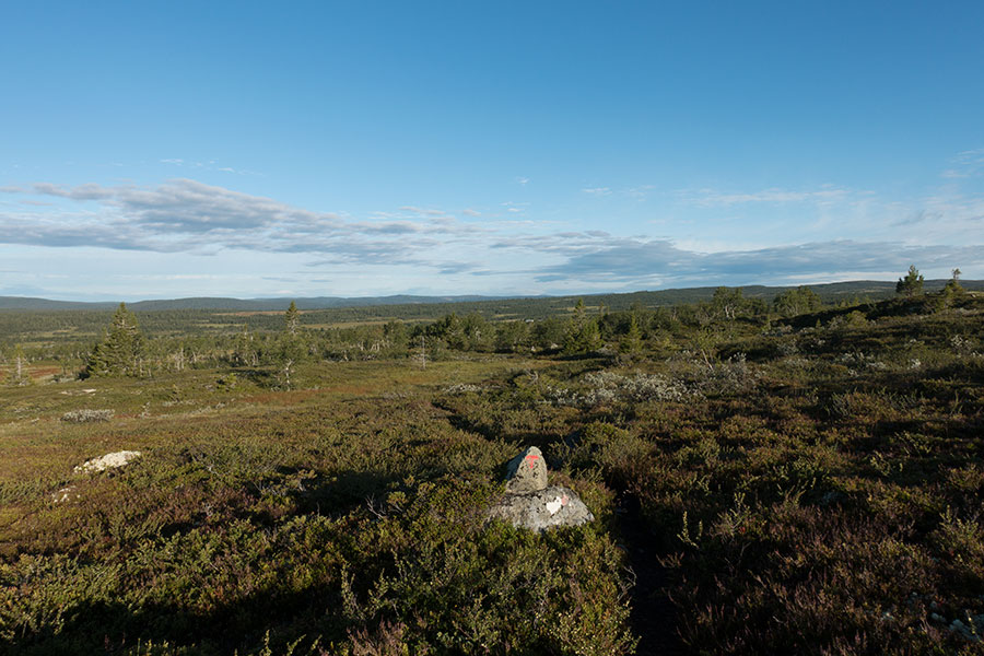
Moorland
It’s mostly easy walking on the moors despite the occasionally rocky tread but the trail keeps on high ground and it’s not boggy. When the route gets to slightly lower ground, it enters the trees, a beautiful, mixed woods of birch and conifers in a very open arrangement with room for grassy bits and colorful bush. It’s like walking through a garden.

Norwegian gardens
I’m typically squeezing two standard, hut-to-hut sections in one day so if I’m actually linking two, as it’s the case today, I’ll have the end-of-the-day hut and the midday hut. I stop in cozy Vetabua for lunch, it’s not yet raining but I welcome, almost need the pantry room after I skipped my only easy chance to resupply. Another double ration of stew goes down.

Lunch stop
I didn’t know much about this area other than what was in the maps, I knew there were trails and I trusted the Norwegian quality to keep it enjoyably walkable but I really didn’t know what to expect once the popular areas were behind so I was glad when I met my first sets of wooden planks over the inevitable marshes. Other than the obvious, the easy progression and the mostly dry feet, the planks meant this was a maintained route and there would be an actual trail to follow, marsh or not.

A trail to follow
After all the forested land, a few dirt roads and a even farm, the trail climbs again to go over a couple of hills before coming down to Djupslia hut. Nice moorland again.

Moorland again
It starts raining barely half an hour before I get to the hut but it’s enough to make me feel more vulnerable that I’d have liked. It’s cold and wet and I’d feel miserable if I wouldn’t know there’s the hut down there. This makes me think I really need to up my game regarding extended self-reliance in rainy weather, be it about gear, mindset or both.
Not today though. Just down from the last hill and into the trees, there’s the short, signposted junction to Djupslia hut. There’s no porch for the interface from dripping-wet to comfortably dry but other than that, the hut is as cozy as you’d expect. I get the fireplace going and I can relax.
There’ll be a couple more parties in the hut that night. Contrary to my uninformed expectations, it’s getting busier since I left the big names behind.
Day 12
There’s data coverage in Djupslia and I can check the weather forecast, which goes from mild to apocalypse rain with every different check. It’s about stormy weather of undetermined duration/violence from the afternoon onwards. I’d happily plan for another hut night but Lyngbua is only 10 km away while the following DNT hut in Oyungen is 30 km more for a total of 40. It might have been a good move to do another very early wake-up call and commit to the 40 km day but the last 15, where I’d get the most of the stormy weather, is over high, exposed moorland so I’m not sure. I resort to taking it easy, see how it feels and decide on the go.
I’m on the trail by 8 AM. It’s overcast, windy and cold. After an initial stretch through the woods, I emerge onto open moorland and it feels like I’m left on my own.

Out of the woods, left on my own
I hike non-stop the 10 km to Lyngbua. This is a small, basic hut that I’m really happy to use for shelter while it occasionally drizzles outside. It’s a bit like the Slash church scene in the November Rain clip, the hut looks tiny from the outside but inside it’s a compact, one room version of all the usual amenities, including a fireplace, a gas stove a few bunk beds. It’s only mid morning but I have my main lunch here.
The weather still holds when I resume the hiking and my position improves when the trail comes down slightly, just enough to get into the woods again and I can feel the shelter from the trees. The sky is still dark grey and I appreciate the nice, dry grass and the tree wall along this section for what would make perfect camping conditions in rough weather but I commit to keep hiking, at least until and if it starts raining.

Grass and trees
I foresee a turning point in Nyskolla, where the trail crosses a dirt road and there are a few cabins. After that, it’s high, open moorland, the place where I wouldn’t like to be if it gets really stormy and it’d be another 15 km to a hut that I can use. It’s mid afternoon when I get to Nyskolla.

Godlidalshytta is not a DNT cabin and I don’t have the key to its lock
It’s right there that the rain starts. In favorable conditions, it’d be a long but very doable journey to the hut in Oyungen but I look up at the high fells, picture myself being beaten by rain and wind for 4 hours and I must admit it’d be a bad idea. Meanwhile, the rain hits hard and gets me really wet in no time. There are still some scattered trees around and I look for shelter from the sideways rain beside one. It’s better than nothing but rather limited protection, there’s no canopy to get under.
I feel so vulnerable that I pity myself. To just get the feeling worse, there are some really nice cabins in the area but none of them seems to be public, none seems be occupied at the time and there doesn’t seem to be any porch, not even a simple overhang. Shelter is so close and so far at the same time.
If I’m not keeping going, I need to camp and make myself comfortable. This should be easy, I’d have thought. I know the ground can get bushy and marshy but I’d have expected it wouldn’t be too bad before climbing to the high ground. That’s probably why I felt particularly silly going back and forth around Nyskolla trying in vain to find a suitable spot while getting more wet. It’s remarkable how difficult it can get and I miss the near perfect conditions only a few km back.
Eventually, I find a grassy strip that’s mostly dry underfoot and where I can even get some meaningful windbreak from the low bush. By the time I finish pitching, it’s nearly stopped raining.

A very nice camp spot, eventually
It will not rain again that day but I won’t regret having stayed even though I’m not used to camp that early. It will actually be a very nice, relaxing time, made much easier by the calming weather with only a mild breeze and several breaks in the clouds that even let some sunshine through. I set the wet stuff out to dry.

Drying wet stuff in the breeze
I don’t have it clear whether this was a success or a failure story. Whichever way, I’m happy with the final outcome.
Day 13
The following day is a very different story. It’s calm and clear in the morning and it feels great to wake up and climb to the high moors in very good hiking conditions.
Calm and clear at last
The ground is the wettest I’ve found so far on the trip or maybe it’s just that there are no wood plunks over the marshy areas but I can hardly care, wet feet are not a show stopper.

Keeping feet cool
It gets progressively cloudier again and I remember the forecast would call for some chance of rain in the evening but the whole vibe is much quieter than the previous morning. It’s before noon that I go by Oyungen lake, where there are several cabins, the DNT hut among them. I don’t bother with the 1 km detour.

Oyungen Lake
Past Oyungen, the map shows a very flat and marshy area that goes on forever across Raudfjellet and that’s just what I get. It’s a bit of a slog that I need to take with patience but otherwise easy and the light makes the marshland shine in strong contrast with the so far dominant grey gloom. I find it really pretty.

Dark clouds, shiny marsh

Hedmarksvidda marshlands
I eventually get to the edge of the fell and start coming down knowing that never again in the trip I’ll be back to this high moor environment. It’s only a couple of days left that will be very different from everything else I’ve so far hiked. I get into the trees but not the usual stunted birch, full size conifer instead.

Full size trees
The sky has turned overcast but I couldn’t care less, my plan is for one final hut night provided that there’s a small, quiet cabin at the perfect distance. It doesn’t look like it’ll rain much but these woods are not very welcoming to camping anyway, the ground is very bumpy and bushy. At the turn of the evening, I get to strangely named Halgutusveen hut.

Halgutusveen
Halgutusveen is a nice, simple cabin with just a staying room and a sleeping room, not even fully separated from each other. I could have camped somewhere outside but I take this chance as the first chapter of my saying goodbye to the outstanding features of this trip. As I had expected in this seemingly not so popular area, I’m on my own and I like the quietness of the cabin in the woods. It’ll be a very nice stay.
Day 14
In the morning, it’s only thin, high clouds veiling the sun and no wind. Going with the weather, I feel relaxed, only two days worth of walking ahead and they don’t even need to be particularly long, it’s like I’m almost there.
I keep the downhill through the conifer woods all the way to Astdalen, where I meet a dirt road and several cabins. This is the first time I come down to a main valley since the gap between Trollheimen and Dovrefjell on day 5. At nearly 400 m, this is the lowest I’ve been on the trail since then. The Asta flow and the thick conifer woods make for a completely new environment that reminds me a lot to the North-American west.

Astdalen
I need to parallel the Asta downstream for a few miles going deep through the Norwegian rainforest, a lush and somewhat oppressing environment, rather dark even in the mildly bright weather conditions. It’s really beautiful and I appreciate the dramatic change.

Norwegian rainforest
From Astdalen, there’ll still be another highland section before the final climb down to trip’s end but it’ll keep me around the 700-800 m mark so I will never leave the tree line again. As I hike up from the valley bottom, the trees are still old and big but the arrangement is more open.

Brighter woods higher up
It’s lovely walking through the woods on a good, dry trail which turns into marsh every time the terrain levels. I go by a couple of basic huts, smaller but otherwise similar to the one I had used the previous night, as well as up and down several hills in an attempt to keep to the dry ground. At some point, the marshland wins and I have several miles of boggy ground. The sky is a kaleidoscope of blue, black and other shades of grey with the occasional shower visible in the horizon but it never feels like it’ll rain on me. When the sun hits the marshland grass, it gets real shiny.

Shiny marsh again
As I cross Malifjellet, I can feel how I get closer to the urban areas. I reach the dead end of a dirt road at a super-lovely setting where there are several cabins, one of them a DNT hut that had somehow become my beacon for this final section of trip: if I’d get to Malia, I’d be through and the rest should be a formality, a day walk to trip end and not even a very long one.

Malia
I’d be tempted to stay here for the night and enjoy the view to the northwest as the sun sets over the fells but the weather feels peaceful enough despite the clouds and I know I’ll enjoy a final camp much better so I keep going. Here I leave the Rondanestien Route I had been following for about a week.
The challenge is to feel confident about finding ground suitable for a camp for someone not familiar with this kind of terrain but it’s straightforward to get the basics: low and flat means bog and slopes are sloping (this I already knew) so I aim for the hilltops. Those can be boggy too but there seems to always be islands of firm ground. I find mine in due time. As the clouds fade away, I can still enjoy the long sunset of the northern latitudes.

Final camp
The terrain is rather flat and lacking perspective but I do have some views to the north:

Views to the north
I’ll dearly love this final night on the trail. Solitary, calm, peaceful, job done, just relax and take the place in.
Day 15
I’ve camped only 25 km from the train station in Hamar town, out of which the final 16 are on a tarmac road, i.e. I’m almost there. I still do an early wake-up call so I can be sure I’ll get the afternoon service to Oslo. Due southwest for my final miles on trail, I alternate pine woods and grassy bogs. The area must be popular with winter backcountry skiing, as evidenced by the tall route markers. The summer trail is often provided with wooden planks over the marsh.

Planks for summer hiking, high markers for winter skiing across the marsh
It’s only 6 km on trails. I step in the water on the last stream before the gravel so I reach the urban world with wet but clean feet and shoes. Then I emerge onto this:

Out to the gravel road
A whole new experience in hiking begins on a dry, level surface flanked by woods. It’s short-lived, only 3 km to the hard-surfaced network in Gasbu, just a few roadside buildings servicing the winter skiing, all very quiet in the middle of August. And a new breed of signaling:

Final 15
It’s a long way to be on a road and there should be some bus running down sometime but at this point I quite like the idea of walking train station to train station and I take it as a chance for some easy progression on a trip where there wasn’t much of it. It’s 400 vertical meters downhill but the relief is smooth enough that I don’t get many great views of my destination. It’s down there, by the lake:

Hamar town down there
I enter town before noon with still a couple of hours left before I can take the train. Hamar feels sleepy on a Saturday morning. I need to go all the way across town for the train station with no plans to move from there.

Hamar downtown

Hamar train station
The rather plasticky station cafe may not be the fanciest of restaurants but I surely get my first foody fix based on pizza and coffee out of the very limited offer in hot stuff. In my own food bag, literally a mouthful of trail mix and a few bread sticks is all that’s left.
 RSS – Posts
Say what you want