
It used to be called the Alpine Pass Route so you can bet the passes are an important feature. They always are on mountain terrain! They’re the main landmarks to help us break the trail down into meaningful stages, they’re the double-side viewpoints and they decide where the water goes. This is a power list of the passes I crossed on the Via Alpina.
Foopass
| Altitude | 2223 m / 7293 ft |
| Watershed | Seez-Sernf |
| When | Day 1 |
| Type | Broad, grassy |
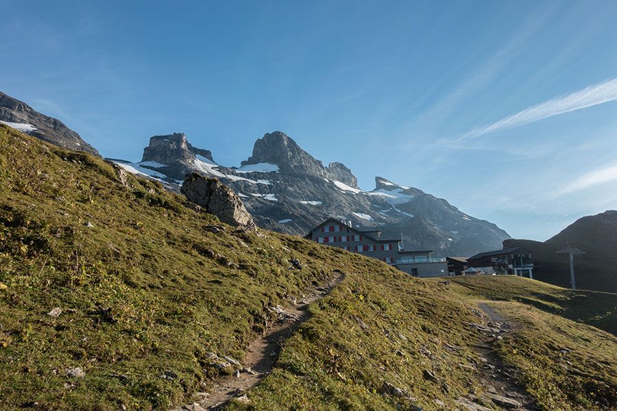
Quickly renamed to Foo Fighters Pass as I was walking along. It’s a very long approach from Sargans that summarizes well what the Via Alpina 1 is about: woods, meadows, slope traverses, steep trails, level trails, waterfalls, hamlets, alp locations, cattle herds and eventually a grassy approach, very easy in calm weather.
I crossed Foopass in late afternoon with the sun on my face so any descriptive pic needs to be backwards:
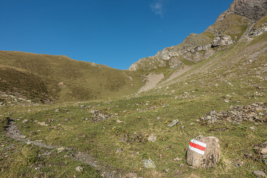
Foopass west side
Foo has great camping options, quiet, grassy and level on both sides of the pass.
Richetlipass
| Altitude | 2261 m / 7418 ft |
| Watershed | Sernf-Linth |
| When | Day 2 |
| Type | Broad, grassy |
Richetli turned out to be one of my favorite passes of the trip with a beautiful, grassy, flat basin on the east side approach and great mountain views on the west, leading down close to the headwaters of an impressive valley. It is the paradigm pass. If you ask a child to draw a mountain saddle, it’ll draw Richetli. If you ask me, I’ll do the same.
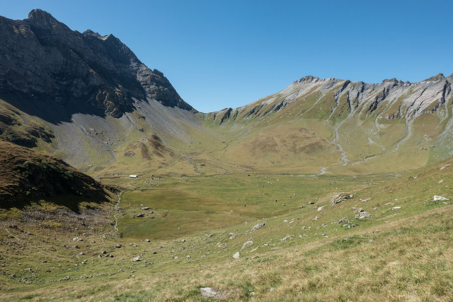
Richetlipass east side
Richetli has great camping on the east side even though you’d like to hide from the alp building and it might get tricky to find accommodation among all the cow pies. The west side hardly has any flat area until the very valley bottom but I’m sure a big enough, level enough spot could be found. There’s a small hut just below the pass that was open as I walked past but I’m not sure it’s meant for public use.
Klausenpass
| Altitude | 1948 m / 6391 ft |
| Watershed | Linth-Reuss |
| When | Day 3 |
| Type | Road link |
Klausen is fully occupied by a rather hefty road even though the climb on both sides is all on trail but it’s certainly not the most attractive of passes. There’s a couple of pubs on the saddle. It’d be a good pass to cross on a rainy day.
Unattractive Klausenpass
Wild camping would be technically possible on either side below the saddle but you’d be a stone throw from the road and most probably in direct view of it.
Surenenpass
| Altitude | 2291 m / 7516 ft |
| Watershed | Reuss-Engelberg Aa |
| When | Day 4 |
| Type | Broad, grassy |
Surenen has a very mountain feel and it’s the first time as you head west that you walk on scree slopes on the climb up. The Via Alpina approaches from a side ridge instead of following the valley bottom where there’s also a trail that would be less panoramic but a more natural progression. It’s a beautiful climb nonetheless.
Surenenpass east side
Camping would be fine on the east side, albeit a bit stony from the rockfall from the walls on the south flank. The west side has a lovely basin with great grass and running streams. There’s also a small, emergency hut just below the pass.
Jochpass
| Altitude | 2207 m / 7241 ft |
| Watershed | Engelberg Aa-Aare |
| When | Day 4 |
| Type | Broad, built-up |
This is a naturally spectacular pass now ruined by infrastructure. It’s the first time that you get really close to a glacier as you proceed west along the Via Alpina but it’s difficult to focus on the ice among all the buildings, cable cars and power lines. I crossed in the early evening and the place felt eerie with no one around even though it was probably inhabited. The most hiker-friendly thing is the water trough.
Jochpass. It’d be great if it wasn’t for all the buildings
There’s good ground for camping on both sides of the pass but you’d want to get well away from all the noise. The west side is quieter but beware of the special protection area around the Engstlensee.
Grosse Scheidegg
| Altitude | 1962 m / 6437 ft |
| Watershed | Aare-Lutschine |
| When | Day 6 |
| Type | Minor road & Hotel |
This is where the Via Alpina 1 starts to look like a walk in the park. Grosse and Kleine Scheidegg are relatively low passes, hardly anywhere above the treeline and choked with human print. To compensate, the mountain scenery above and around is among the most spectacular of the whole route with icons such as the Wetterhorn, Eiger and Jungfrau.
Grosse Scheidegg is actually lower altitude than the Kleine, despite the names that might suggest the contrary. It goes over the main ridge off the Wetterhorn at the point where it levels off after its almost vertical drop. There’s a minor road across the pass and a berghaus hotel at the very saddle.
Grosse Scheidegg east side in center midfield at the base of the Wetterhorn. The pointy Eiger is lurking behind
Despite the road this was a very nice and pleasant climb, particularly while going up on the east side along a beautiful valley with spectacular views of the mighty Wetterhorn above. I had my best camping spot of the whole route on a nice meadow at the base of the mountain just east of the pass. The west side looked less intimate but the woods would provide enough hideaway for a fair camp.
Kleine Scheidegg
| Altitude | 2061 m / 6762 ft |
| Watershed | Schwarze Lutschine-Weisse Lutschine |
| When | Day 6 |
| Type | Rail link, built-up |
This one goes over the main ridge off the Eiger. The saddle area has been obliterated by the mini-town that sits on top. There’s a dirt road across the pass, apparently not open to the motorized public but the main transport means is the cog railway that climbs from both sides as well as up from the pass into the Jungfrau massif to a crazy height above 3000 m.
Kleine Scheidegg is a major tourist trap and a very low emotional point for a hiking route. The railway however is far less intrusive than a public road would be. The main station building is nice and the restaurant inside feels like and old, early 20th century movie. It felt welcoming to me when I got to the pass as it was starting to rain and getting cold outside.
Kleine Scheidegg east side at the base of the Eiger
I wouldn’t like to camp anywhere near Kleine Scheidegg anyway.
Sefinenfurkke
| Altitude | 2612 m / 8570 ft |
| Watershed | Lutschine-Gornern |
| When | Day 7 |
| Type | Rocky notch |
Also spelled Sefinenfurke or Sefinenfurgge, this one is completely different from all the previous passes on a westbound trip, not only for the name format but also because it’s the first one that’s not broad or grassy but rocky and craggy. Its rough character was strengthened when I crossed by the fog as if the shale rock was not dark enough.
I completely missed the views and it was actually difficult to have any form of a good time as by the time I crossed the pass I was feeling definitely ill and it was only getting worse as the day progressed, yet it was still so welcome to be back in some real mountain environment for a change.
The trail is steep on both sides of the pass but otherwise easy in normal conditions. There’s a rope handhold both up and down and several lengths of wooden steps on the particularly steep west side.
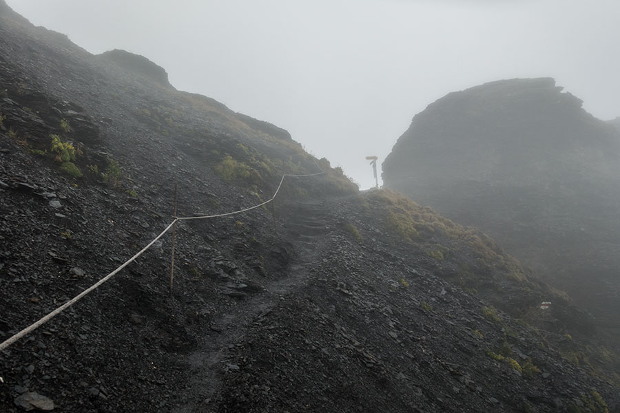
Sefinenfurkke east side
Level grass is available on both sides, well below the pass. It’d probably make for great camping spots.
Hohturli
| Altitude | 2778 m / 9114 ft |
| Watershed | Gornern-Kander |
| When | Day 8 |
| Type | Rocky notch |
Highest pass of the route that turned out to be my favorite for several reasons, some owing to its own character as a rocky notch on a ridge just below the hanging glaciers of the Blumlisalp, a much quieter area than its neighboring valleys to the east, some to the circumstances of a beautiful, crisp morning with a cloud inversion and a recovered health on my part.
The east side is steep and dramatic and has a rope handrail that you probably won’t need in normal conditions. The west side is gentler on a slope traverse and it has the best glacier views of the whole of the Via Alpina 1.

Hohturli, looking south
You’d need to go down quite a ways on either side to find flat grass to pitch for the night but it’d probably make for a memorable spot. There’s a stuffed hut just 5 minutes walk above the pass on a bench on the main ridge.
Bunderchrinde
| Altitude | 2385 m / 7825 ft |
| Watershed | Kander-Entschlige |
| When | Day 8 |
| Type | Rocky notch |
Bunderchrinde is the third rocky pass in a westbound row but it’s much gentler than the two previous ones. Once again I lost the views to the fog but it was that same fog and the evening timing of the climb that made me feel here more on my own that I had ever felt along the route and I loved that feeling.

Bunderchrinde final steps from the east
The highest grassy flats on the east side appeared exposed and unwelcoming in the dark environment I went through. There were better sheltered spots on the climb down on the west side.
Bunderchrinde was my final pass on the Via Alpina after 8 days of hiking.
The rest
I climbed all the major passes but I missed the easternmost section of the Via Alpina 1 and the crossings of Hahnenmoospass, Trüttlisbergpass, Col de Jable and Col de Chaude, missing also the transition from German to French. Such interesting names, I love how languages portray the landscape. Other than that, these last four remain unknown to me. A la prochain foi.
 RSS – Posts
Say what you want