
 Initial stage of my trip on the Via Alpina 1: the Weisstannental and my first ever Swiss Alpine pass
 Stage 2 of my trip on the Via Alpina 1: from the Sernftal to Urner Boden
 Stage 3 of the Via Alpina 1: Klausenpass, a long descent and a big, flat valley plus my first real crisis of the trip
 Via Alpina 1, Stage 4: one high pass in the morning, a second one in the evening and everything in between
 Stage 5 of my trip on the Via Alpina 1: the Planplatten ridge, postcard panoramas and a camp spot guarded by the Wetterhorn
 Via Alpina 1, Stage 6: the two towers (a.k.a. Wetterhorn and Eiger)
 Day 7 on the Via Alpina: dark weather, dark rock and the toughest side of thru-hiking when the body doesn't work
 8 is the final day of my trip on the Via Alpina, coming out of illness to climb the last passes with the odd names
Tag: Via Alpina

| Where | Switzerland |
| When | September |
| Distance | 268 km / 167 miles |
| Length | 8 days |

The Blümlisalp massif from Hohtürli, highest pass on the Via Alpina 1
| Start | Bundalp |
| End | Adelboden |
| Distance | 31 km / 19 m |
| Passes | Hohtürli, Bunderchrinde |
I wake up wondering if I’ll be fit for walking today. It’s difficult to say when nothing really hurts and a resting position makes everything feel right. Straight off bed I feel weak but that may be normal. I decide to give breakfast a go and see how it feels. It went down this well:

Alp breakfast

| Start | Lauterbrunnen |
| End | Bundalp |
| Distance | 24 km / 15 m |
| Passes | Sefinenfurkke |
For the first time in the trip, the day starts overcast. Chance of rain in the morning, getting dryer in the evening. Me, climbing right away, pretty much off the hostel door and up the glacial escarpment with interesting views back to Lauterbrunnen.

Lauterbrunnen from the other side

| Start | Wetterhorn base |
| End | Lauterbrunnen |
| Distance | 29 km / 18 m |
| Passes | Grosse Scheidegg, Kleine Scheidegg |
After the early night thunderstorm, the morning is crisp and clear. The Wetterhorn is still there.

Dawn on the Wetterhorn

| Start | Engstlensee |
| End | Wetterhorn foot |
| Distance | 33 km / 20 m |
| Passes | None |
I’m glad I slept under tree cover, the Alps are a surprisingly damp place! but my shelter is mostly dry in the early morning and I didn’t need to compromise on views.

Dawn on the Engstlensee, Jochpass at the far end

| Start | Brüsti |
| End | Engstlensee |
| Distance | 36 km / 22 m |
| Passes | Surenenpass, Jochpass |
Morning is brilliant blue and it doesn’t take as long as on previous mornings for the light to shine, it’s the first time on the trip that I don’t sleep on the valley floor. I couldn’t arrange for tree cover overhead for the night but my shelter is dry nevertheless. Surenenpass is still there and it’s my next milestone.

Trailstar in the meadow, Surenenpass at the far end

| Start | Urnerboden |
| End | Brüsti - Attinghausen |
| Distance | 33 km / 20 m |
| Passes | Klausenpass |
In the morning, as expected, everything is dripping wet and I need to leave well before the sun shines so I pack a wet mess and a good excuse for an extended break in the sun later on the day. The setting is not idyllic, too close to human habitation but the valley is beautiful and very well worth a camp pic:

Dawn in Urner Boden

| Start | Elm |
| End | Urnerboden |
| Distance | 42 km / 26 m |
| Passes | Richetlipass |
Morning is dark inside the thick conifer woods where I’m camping just outside Elm village. I go through town in daylight but still well before the sun rises above the mountain tops. My legs are sore from day 1 efforts that no amount of stretching could heal but as soon as I warm them up, I can walk with reasonable dignity.

Morning in the conifer woods

| Start | Sargans |
| End | Elm |
| Distance | 36 km / 22 m |
| Passes | Foopass |
Sargans and nearby Mels sit in a wide, oddly flat valley confluence flanked by high peaks. The Via Alpina 1 enters the mountains along the Weisstannental in a course due west. This valley is narrow and deep, with a public road near stream level. The trail takes a different course on the upper floor, i.e. it makes an initial climb to the south-side slopes, then traverses along, linking the small communities and farms clinging to the hillside.
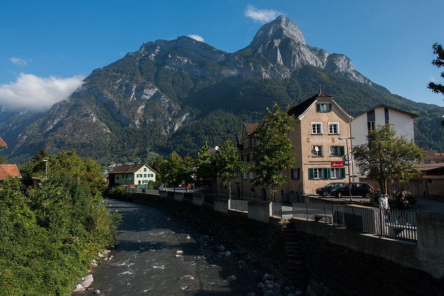
The Seez in Mels
Via Alpina 1 is the newer name for the trail formerly known as the Alpine Pass Route. It goes East to West along the northern edge of the Swiss Alps from Liechtenstein to Lac Leman for a length of about 360 km, more or less depending on a few existing options.

The Via Alpina 1, also known as the Alpine Pass Route goes east to west across Switzerland through the Glarner and Berner sections of the Alps for about 360 km, give or take some depending on options and starting point. I hiked along in mid September, 2018 with the loose, ambitious idea of completing it in a week. I didn’t make it to the opposite end but I did make a lot of other stuff. This here is a list of the aspects that left a lasting impression on me. It’s about the land, the mountains and the trail and it’s mostly about myself and how I was feeling at the time.
Starting mid September, I’ll be hiking on the Via Alpina 1 all the way across Switzerland. Background, motivation and rough plan below.
 RSS – Posts