
Category: Trips Page 3 of 4
Distance covered: 25 miles
I’m happy to face one final road walk today. The wimp in me got scared yesterday and I’m fine with that middle ground in not giving up but taking the less compromising route. It won’t be a memorable journey but I’ll be worry free no matter the weather. Real wilderness will need to wait a bit longer.
Distance covered: 28 miles
It starts overcast and windy, at least the wind will be on my back. The other good news is that I’ll be on a real hiking trail today. A rare, welcome event, I won’t find another such trail until the final 2 days of the trip. I also know this trail is easy to follow, not only from reports but from previous, own experience, and this is the other, funny part: I was hiking on this trail 16 years back, no less. Back then, the same northerlies as expected today left me dripping wet and cold to the point that I bailed out mid-way. I’m here now to fill that gap.
Distance covered: 29 miles
Day 2 is typically a tough one in fastpacking trips with no quarter. It is the day when the body is already beaten by the previous day’s effort but not yet used to the constant beating of a thru-hike. I can’t take it easy though. If I mean to cross Iceland in 13 days, I can’t just take it easy, not even for one day, not even for day 2.
Distance covered: 28 miles
It’s overcast and gloomy as I wake up in Akureyri but I commit to not worry about the weather, at least until I start the actual hiking. I still need to get to the starting point and that is a few hours bus ride away. This is Iceland and the most mundane bus trip is a spectacular event so I sit back and relax.
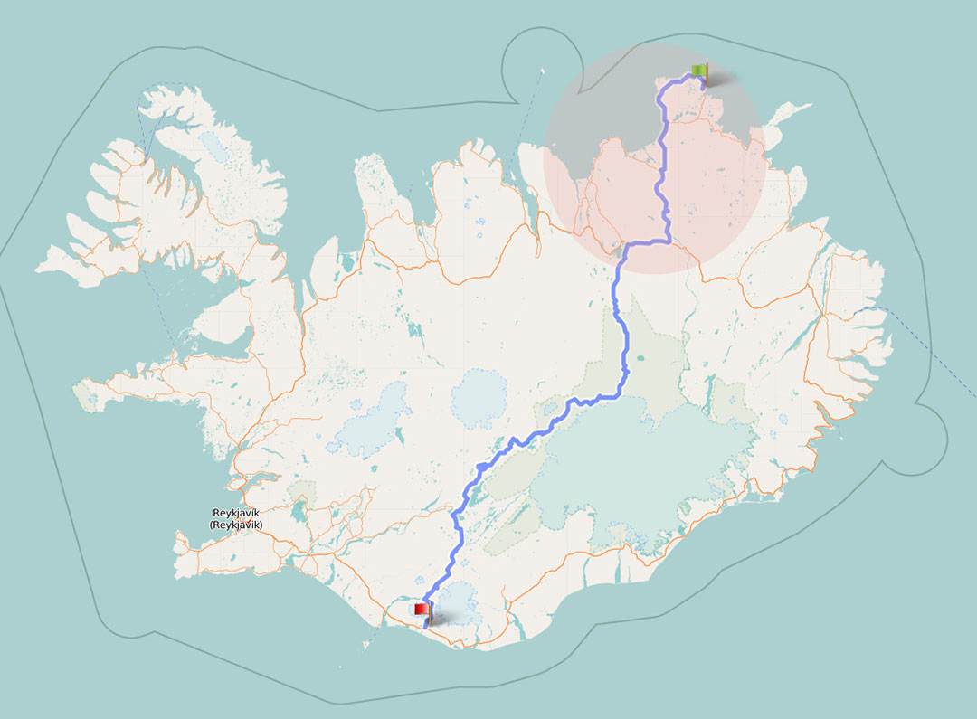
| Where | Iceland |
| When | July/August |
| Distance | 546 km / 340 miles |
| Length | 13 days |

Across Iceland, north to south
Pack / Tent / Sleeping bag / Mat / Stuff sacks / Clothing / Towel / Poles / Stove
This is about gear, Iceland and myself. It’s all mixed together. I mean to assess how my kit worked in Iceland but some of the sections are necessarily decontextualized, if only because I love to talk about gear, in essence because I’m talking about myself.
Jon Ley’s Plhumf.com website is almost as old school as mine but I needed to look nearly nowhere else. His 2006 trip fits exactly my idea for this traverse and I’ll actually be following his footsteps as long as they haven’t been erased by some new lava flow.
Access / Direction of travel / Hiking window / Maps / Digital / Resupply / Fuel / Huts / SAR
The information here is what I’d needed to know when planning this trip. It is organized in a north to south fashion, where applicable. It should be easy to apply to a south to north trip anyway.
Cool facts / Terrain & Relief / Hiking grounds / Camping / Weather / Wildlife / Landscape
It was this beautiful. Consistently
Hiking coast-to-coast-something is a very powerful idea, it just makes sense from a travelling standpoint. It gives the traveler perspective over the territory. It makes for a trip with a beginning and an end.

Final steps of the traverse. The Atlantic in the background
Crossing Iceland was intense. Here are a few relevant thoughts
I dream of the gear I’ll take to Iceland. These are my current thoughts:
Shelter
Stephenson’s Warmlite 2C

Wamlite 2C in the Lapland hills
It’s exposed and potentially windy in the Iceland highlands so the shelter of choice must be wind-worthy. The other key factor in shelter choice is sandstorms, which may not be an obvious feature of a sub-polar region but it is in this particular case: Iceland is all lava. In the highlands, fine volcanic dust covers wide areas devoid of any vegetation that could help stopping it being blown around. When it is, it gets into the most intimate corners.


Hiking the crest
The Cantabrian Ranges run parallel to the Iberian peninsula northern coast for 300 km as the crow flies. It’s a region of grand beauty, complex geology and wicked weather patterns that make hiking a challenge. It’s the mountains, they’re big and we are small.
Thru-hiking the watershed divide is a tough call. Doing it in November adds to the challenge.
A one week allowance is not enough to hike the whole thing. What follows is an account of a 180 km route along the Cantabrian crest divide. 8 days hiking among the limestone giants.

The Blue Line between A and B
The complete High Route in the Cantabrian Watershed divide would take at least 2 weeks to cover to a strong, committed hiker. This trip was 8 days long in a season where daylight is getting short, no way I could hike the whole thing. I had a starting point and a way to go. The goal was to hike and be on my own for 8 days in the most magnificent of sceneries.
View route map for Cantabrian High Route Pajares Piedrasluengas on plotaroute.com
I didn’t record the hike so the plot above, drawn by hand, is not accurate, neither is the distance, which came out to 180 km (112 miles)
The menu on the right has the stage breakdown. The names will be meaningless but I need to put a name to the places!
You won’t find many resources on this route in anything that’s not Spanish. Actually, there aren’t many in Spanish either. Most internet resources and guidebooks focus on one-day activities and most of them will be about climbing peaks. Overnighting outside is not a popular thing, neither is long distance hiking.
The high pressure conditions remain and the weather should be clear. I don’t know what caused yesterday’s fogs, maybe some cold air mass in the area. I would expect a new, clear day today no matter how dark and thick the fog was yesterday but I have a plan in case it remains: the track I was following would actually take me out of the mountains. It’d be acceptable given this is my last day of hiking.
I wake up to a dry tarp and a view of a frosty valley below, fully endorsing yesterday’s camp choice. Actual site and orientation missed the best mountain view but I could see sunset and sunrise instead:

Good morning
In my lowest altitude camp I wake up to negative temps, high humidity and a good frost all over the place as a consequence. This is a classic example of temp inversion driven by sustained high pressure conditions: cold air sinks and humidity condenses. During the night there’s no sun to warm things up so the system stays locked.
In the morning my tarp is dry and the grass around is dry as the valley bottom has frosted over. What a huge difference a short distance can make in the camping experience and how much nicer it is to pack a dry shelter.

Frost in the valley below
A small cirque at the very headwaters of a cantabrian valley, that’s the definition of the perfect overnight spot and I feel fortunate to wake up in such glorious place. The only downside in a mid-November morning is how long the sun takes to shine. I leave the area before I get a chance of getting any warmth. Morning lights are beautiful anyway.
Yesterday’s last effort was more than a last push for the sake of performance, it was also a statement.
It’s often easy to skip crest sections by joining saddles along the slopes or the base of the hill. This is fine as it is all part of what a High Route means: the idea is to follow a coherent line along the divide. Then there are cases like yesterday evening’s: the road to the ski resort runs parallel to the divide crest and leads to a gentle climb back to the top on a service track. I could have done all that in less than a couple of hours. It is not cheating, it’s just the -in this case- easy way.
The night goes in between heaven and hell. Heaven because that’s what the night usually is: a time to relax, do nothing but rest, heal the wounds of the day’s work, feel at peace with the world. Hell because sometimes the world gets aggressive and you become a tiny piece of nothing at its mercy.
I took the early morning train from Leon to Busdongo de Arbas, 4 km down the road from the Pajares pass in the divide. The train line goes north across the plains and into the foothill mountains, along a narrow, winding valley.
I took the divide at the Pajares road pass after a short hike up the road from the nearest railway station. The choice wasn’t random: that’s where my previous hike in the High Route finished a few years back. I would hike east and as far as I could go in 8 full hiking days.
This is very personal and only tangential to the actual route. It’s about challenges, fears and how I’d cope with it all. The challenge will be at a rather emotional level.

Day 6: when my smile was genuine
Hiking the High Route in the off-season was something I could do. Feeling comfortable about it was a different thing. This latter was my challenge.
This is a summary of some specifics about the Cantabrian Ranges and their High Route traverse.

Hiking the crest
Summer-style, multi-day backpacking in late fall requires some adaptation, not only in the gear: I usually take lower level, less exposed routes and/or plan for less days out in a row. This time I chose a summer route in summer style: 8 hiking days, self supported and a seamlessly compromising location.
November is a tricky time to backpack in the northern Iberia ranges: weather can be anything in a wide range of scenarios. One of them is very harsh, including cold, wet, fog, snow or the whole bunch.

The Cantabrian Ranges

Making friends at the Combe de Crousette
| Where | Western Alps |
| When | August/September |
| Distance | 852 km / 530 miles |
| Length | 24 days |
There’s lots of user information about the Alps already, yet traversing a significant section of the range while camping out most nights, packing several days worth of food at a time or not climbing any peaks is probably not the most typical activity people do in these mountains.
During the GR 5 traverse, I was never more than a couple hours hike from some kind of civilization and if I count on the stuffed huts that couple of hours happened very few times, if any. The Alps are no wilderness and the GR 5 is certainly not the most remote you can get in these mountains. It’s dead easy and requires no big planning effort to hike the GR 5 and get lodging every night.
In my very limited experience, lots of people use the GR 5 trail system but it seems not many try to hike it all and even less attempt any kind of extended self sufficiency. It will be odd to leave the last village only to climb up to some alpine meadow for camping but once there you’ll quickly forget the taverns you missed. It’s beautiful up in the alpine and these mountains are famous for a reason or two.
The Alps don’t stand out for the wildness and there are no big mammals to worry about. The goat-like chamois and bouquetin seem the most ubiquitous among the sizeable ones, relatively easy to spot and I never seem to remember which one is each.
Another common trail companion is the shy marmot, bound to be the main character in this comment.
The GR 5 is well documented. As any GR trail in France, it’s got its own set of guidebooks, consistently edited by the FFRP (Fédération Française de la Randonnée Pédestre which approximately stands for French Hiking Federation). These books are in French and due to the popularity of this route among English speaking (or, in general, non-French speaking) people, UK publisher Cicerone released a guidebook that covers just the Alpine Traverse.
Most of the stuff is just as usual. I’ll comment on those new or somehow relevant items.
Shoes
Inov8 Terroc 330
Maybe the most comfortable shoes I’ve worn on the trail, surely the lightest and probably the less durable. The Terrocs performed well and were very gentle on my feet but barely made it to trip end. The shoe body was still ok but the soles suffered; one of them got a crack under the ball of the foot that turned into an alpine glacier crevasse exposing the midsole which eventually also cracked.
Going through villages is something that happens almost everyday on the GR 5; usually, more than once a day so it’s a key part of the experience. With recreation being such a big part of the scene in the Alps, it’s taken over a lot of the rural environment and some locations have more lodges and restaurants than farms and sheds. I tried to not spend much time in the urban but still feel a quick overview of what can be expected might be of interest. North to south:
Is there anything I can write about the Alps that’s not already been said? Probably not except my own take at one of the most spectacular, long distance traverses along the western arm of one the most spectacular mountain ranges. A bit of blah, blah, blah too…
The word alpine comes obviously from the Alps even though it’s evolved into a kind of generic term for everything alpine. But strictly speaking an alpine something should take place in some alps. There are actually a few mountain groups in the world named alps but it all began where the European plains rise several thousand meters to become a world of rocky, ice-covered big walls that define the line between north and south; east and west, too.
The Rockies are the most famed north-american mountains, a huge range of a size and extension owing to the local scale of things: everything is big in America and so is its mountainous spine.
| Where | Colorado Rockies |
| When | August/September |
| Distance | 800 km / 500 miles |
| Length | 25 days |

Cataract Ridge in the San Juan Mountains
I had barely visited a lesser section of the Rockies so this was pretty much my real introduction to the range. By hiking a significant section of their length, I’d hope to experience the same attraction that led my story in the ranges farther west.
The Rockies may be known for their rocks but it took several days until the trees allowed any significant rocky view. I spent many hours and days walking in the woods to the point that I started calling them “The Woodies”. Not sure I’m allowed to play with the words in a language I don’t know.
The Colorado Trail was the perfect length for my 4 week holiday window and it had been in the planning stages before. 2008 was the year I’d travel the Rockies.
As this is no fashion show, there’s not new gear every season and many items are the same as those for previous trips. Most key items are. I won’t be commenting again on those that already were in 2007 or 06 and I’ll focus on the new items or the new life from old ones. As usual, there’ll be a few lessons learned.
The Colorado Trail Foundation is the obvious and basic starting point for any prospect CT traveler. They take care of anything trail related and their website is full of all that information one needs one one knows nothing. Plus the e-shop gives access to the paperwork, plain or e-

Official guidebook from the Colorado Trail Foundation

Same book
This is the west and the Rockies are the great barrier that defines what’s beyond as the Far West: the Colorado Trail traverses the Front Ranges of the Rockies and then travels along the main divide of North America.
The big mountain ranges usually make a difference as to the climate that can be found on either side. Not so much with the Colorado Rockies: big mountains but too far from the oceans, the Rockies don’t trap the weather; rather, they create their own weather.

Weminuche Wilderness, CDT & CT share the trail
Expectations vs. Reality
I’m used (with a reason) to think of America as the place of the big, open spaces where one can be well away from the human things. I appreciate that as much as I miss it in over-stuffed Europe and that’s basically why I keep coming back.

The Sawatch Range
Ever since I started doing multi-week hiking trips, a few years back, I felt I was going one step forward every time. Maybe several steps forward: longer, more difficult, more remote… in 2008, though, the Colorado Trail left me with this Deja Vu impression and the feeling that I had already done this before. But maybe I shouldn’t be starting here with a seemingly negative comment on an otherwise wonderful trip that basically reaffirmed my faith on backpacking as my best battery charger and necessary break from the modern. And the Colorado Rockies are a great place to feel the noise.
The north american wilderness has this certain attractive: it may be easy, smooth going but also remote and solitary. Miles and miles of uninhabitted land not because conditions were consistently too tough but because there were better places and yet huge chunks of terrain were spared from human occupation. Now they may be visited by hikers and I enfasise the fact that we are visitors in some other’s home. We’ll try to be respectful and enjoy.
Pic from the Colorado Trail Foundation

Baugevatnet, arctic Norway
| Where | Lapland |
| When | August/September |
| Distance | 800 km / 500 miles |
| Length | 24 days |
Hiking beyond the arctic circle may sound like a very extreme thing to do. I’d had pictured a world of summer under freezing temps and windswept barrens.
There’s such conditions north of the circle but Lapland has a weather of its own thanks to the Gulf Stream. There’s human activity up there. There’s even hiking trails.
Planning for this route wasn’t easy. At the time, there was little information, either on the net or in print, and only little bits could be found in English or any other language I could understand. In the following pages, I’ll try to fill that gap from the (necessarily limited) perspective of a one time hiker. Don’t expect a deep knowledge from the area here but I’ll try to stick to the facts as I perceived them and not make assumptions. Or say so when I do.

Handy scale in Alesjaure

At nearly max weight for the trip with 11 days worth of food
One of the issues with ultralight or lightweight hiking is overcoming the fear of being unprepared for the conditions. It’s something you learn with practice but that fear comes back when you face a new set of conditions. This is particularly true when you’re about to travel to an isolated place with potentially severe weather.
Shelter / Pack / Sleep system / Clothing / Shoes
Nordkalottleden was a bit off the typical 3 season conditions of a temperate climate and I had to make a few adjustments to my gear list to reflect that. There was also quite a bit of uncertainty as I was not so sure about what to expect so it was a bit of a challenge to gather a gear list I could trust and was still reasonably lightweight.
As usual, gear and technique are one in this discussion. It’s not possible to understand one without the other so this will not be a fancy presentation of cool looking equipment but a hands-on essay on how my gear and me got together in the arctic fells.
Access / Ressuply / Huts / Maps / Transport
Planning for this route wasn’t easy. There’s little information, either on the net or in print, and only little bits can be found in english. In the following lines, I’ll try to fill that gap from the (necessaryly limited) perspective of a one time hiker. Don’t expect a deep knowledge from the area. I’ll just try to provide all that info I couldn’t find easily, if at all, and I know now.
 RSS – Posts